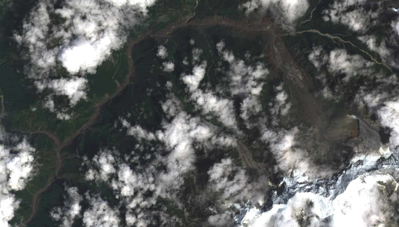
An ‘ice avalanche’ from a glacier is thought to have triggered flash flooding at the Nepal-Tibet border.
Over 160 people are reported to have died, with hundreds missing, including New Zealanders.
The SMC asked landslide, river, and glacier experts to comment.
Dr Tom Robinson, School of Earth and Environment, University of Canterbury, comments:
“The images and videos of massive flash flooding in Tibet and Nepal are horrific, demonstrating the power of such natural hazards. At this stage, there is still much uncertainty over what has happened. From the reports we currently have, it appears that a large landslide has occurred somewhere in Tibet causing part of a glacier to collapse and cascade down the valley for many tens of kilometres. The landslide and glacier collapse itself must have been extremely large – seismic networks in the region recorded the landslide impacting the valley floor as a magnitude 4 earthquake.
“Unfortunately, these kinds of events are not uncommon in the Himalaya. We’ve seen similar massive landslides and floods in the region before: in 2021 two separate events caused huge damage in Melamchi, Nepal and Chamoli, India. Linking these disasters directly to climate change is difficult, however we know that the Himalayan region is already experiencing dramatic effects from our warming world. Glaciers in the region are rapidly melting and destabilizing and when large landslides, which are common in the Himalaya, fall onto them, they can trigger huge rock and ice avalanches that can travel massive distances.
“The first order impacts from these types of events are obvious from the images and videos – tragically we should be prepared for large numbers of fatalities, with early reports already indicating several hundred people have been killed or are missing. There are also likely to be longer term effects as the flood has wiped out critical infrastructure in the valley, including roads, bridges and hydropower stations. Getting access and basic amenities to the affected region will be a significant challenge and it’s clear that this requires a major humanitarian response in one of the poorest countries in the world.”
Conflict of interest statement: “No conflicts to report.”
Associate Professor in River Science Jon Tunnicliffe, University of Auckland, comments:
“First, our thoughts are with the families of those killed and still missing, and with the Nepali and Chinese agencies and communities carrying out the search. The toll includes local residents, workers, pilgrims and travellers from many countries, and it will take time to establish the full scale of the disaster.
“Although this occurred at the height of the monsoon season, significant rainfall does not appear to have been the trigger. Preliminary investigations instead point to a large collapse of glacier ice and rock high above the Lhende Khola. Satellite imagery indicates that the material entered the valley from around 5,200 metres elevation, and investigators are examining whether debris temporarily blocked the river before releasing a much larger surge downstream. River levels at Galchhi reportedly rose by as much as nine metres within thirty minutes.
“That sequence is what geomorphologists call a hazard cascade: instability high on a glacierised slope becomes an ice–rock avalanche; that can block a river, entrain water and sediment, and transform into a debris-laden flood travelling tens of kilometres downstream. Each process is reasonably familiar. The danger lies in the connections between them. A localised failure at more than 5,000 metres can very rapidly become a catastrophe for people far down the valley.
“There is an important climate-change context here, but we need to be careful about attribution. We do not yet know why this particular glacier failed. What we do know is that conditions across the Hindu Kush Himalaya are changing rapidly. Glaciers are retreating, permafrost is degrading, new lakes are forming and steep slopes are being exposed and destabilised. Climate change can amplify hazards that already exist by altering the thresholds at which one process triggers another.
“Sediment is a crucial part of why these cascades are so destructive. Once a surge begins to entrain rock, gravel and boulders, it can grow enormously downstream. It is no longer simply a flood of water, but a fast-moving mixture capable of destroying bridges and buildings and radically reshaping the river channel. Narrow mountain valleys concentrate that energy, while roads, settlements and hydropower infrastructure are often concentrated on those same valley floors.
“The danger also does not necessarily end when the initial surge passes. Fresh deposition can block tributaries, raise riverbeds, divert channels and create new temporary dams. A major event changes the landscape in ways that can generate further hazards over the following days, weeks and sometimes years.
“The broader lesson is that we increasingly need to manage hazard chains rather than individual hazards. Satellite monitoring can identify changing glaciers, lakes and unstable slopes and quickly establish what has happened after an event. That needs to be combined with seismic monitoring, river gauges and warning systems capable of detecting a cascade once it begins.
“Hazard models likewise need to route sediment as well as water, because runout, erosion, deposition and channel switching often determine where the damage occurs. And planning matters just as much as prediction. We will never monitor every unstable slope, so communities need mapped runout corridors, evacuation plans, appropriate land-use controls, and resilient roads, bridges, power and communications.
“Finally, these are international problems. Mountain catchments cross borders, and observations and warnings need to do the same. New Zealand lives with its own versions of cascading mountain hazards — slope failures, landslide dams, debris floods and large sediment pulses moving through river systems. The settings and scales differ, but the underlying lesson is the same: the hazard is often not the first event. It is what that event sets in motion.”
Conflict of interest statement: Not yet received.
Dr Lauren Vargo, Glaciologist, Antarctic Research Centre, Victoria University of Wellington, comments:
“A glacial lake outburst flood is the release of water when the dam of a glacial lake fails, which could be triggered from ice breaking off and falling or avalanching down a valley. It’s unclear if this was the cause of the flood.
“From what I’ve read, scientists who have looked at aerial imagery can see that it looks like a chunk of ice fell from the mountains to the valley floor.
“The location where the seismic activity was recorded is where there are lots of glaciers, but no glacial lake downstream. However, there are other glacier lakes nearby, so without seeing the recent satellite imagery to know exactly where the ice fell from, it’s hard to say.
“We can look at satellite imagery taken before and after the event, and try and see what has changed. Essentially looking for, what is missing from the mountains in the ‘after’ imagery. If we can see if there is ice missing that was there in the ‘before’ imagery, that tells us it was likely ice (likely with some water and rock with it).
“I’m not sure what kind, if any, warning systems exist in this region. My understanding of how this works is that once a breach or surge is detected, signals are sent downstream. The closer communities and infrastructure are to the source of the flood, the less time they would have to respond.
“Theoretically, warming temperatures could melt snow and ice more, making these events more likely. However, I’m not sure if research has been done to formally link increasing temperature and an increase in likelihood of these events. Downstream warning systems can help communities prepare for events like this. We can also monitor the slopes – my understanding is that this is how a community in Blatten, Switzerland, knew there was increased rock/ice avalanche risk in 2025, and evacuated the community downstream before the avalanche occurred. The biggest way to mitigate the risk would be to reduce our greenhouse gas emissions to limit warming.”
Conflict of interest statement: “None.”
Dr Simon Cox, Chief Scientist – Mountains to Sea, Earth Sciences New Zealand, has commented here.
Our colleagues at the AusSMC have also gathered comments. A selection follows.
Dr Soniya Rijal, postdoctoral research associate in the School of Project Management at the University of Sydney, comments:
Note: Dr Rijal is Nepalese, from Kathmandu. Her research expertise includes disaster management, with a focus on how communities organise around extreme events and build resilience ahead of unforeseen disasters.
“The disaster has impacted three districts: Rasuwa (the epicentre of the disaster) on the Nepal-Tibet border, Nuwakot (located southwest of Kathmandu), and Dhading. All are heavily residential. Rasuwa is a popular trekking spot and international trading hub with a large local community.
“Bridges connecting the trade routes from China to Kathmandu have been destroyed, including the highways, severely limiting the flow of goods and services to the impacted areas. Roads have been destroyed, so helping local communities will be difficult. Helicopters have been deployed by the Nepalese government to help those who are stranded. We can’t really see at this early stage how many people have been impacted; it’s possible the impact could be even more devastating than the 7.5 magnitude earthquake that struck Nepal in 2015.
“I’ve heard people were notifying neighbours to leave before the flooding hit, but because there was no rain leading to the flash floods, many of these warnings weren’t taken seriously. What makes this disaster unusual is that it was so sudden, coming without warning.
“The immediate priority should be to search for missing people, and local communities can help do this. Nepal is a very collective society, and locals will have a better idea of how to locate missing people than those without local knowledge.
“Shelter and food will be essential to meet immediate needs. Local communities can work with agencies to oversee the logistical hurdles to deliver essential goods and services. They will also be key to mapping the location of available shelters and storage facilities, e.g. schools, gumbas (Buddhist monasteries) in the immediate aftermath of this disaster. These facilities will be important distribution centres for essential goods and services, and serve as community hubs.”
Soniya has not declared any conflicts of interest.