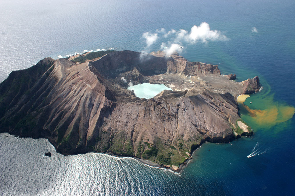
A satellite measuring sulphur dioxide emissions fortuitously passed over Whakaari/White Island almost an hour after its deadly eruption on 9 December 2019, capturing data that is reported on in a new paper in Science Advances.
A team of researchers, including New Zealanders, then looked at similar data from the volcano for the month leading up to and after its eruption. The team says such data captured from satellites can provide new insights into volcanic activity and could potentially aid in detecting precursors to an eruption.
The SMC asked experts to comment on the research.
Dr Craig Miller, Senior Volcano Geophysicist, GNS Science and Dr Bruce Christenson, Volcanic Fluids Geochemist/Lead Scientist – Volcanology & Crustal Fluids Lab, GNS Science, comment:
Note: Craig Miller and Bruce Christenson are co-authors of the paper.
“In this paper we highlighted the capabilities of the TropOMI gas detecting satellite, when coupled with high-resolution wind models, to recover the degassing history of Whakaari shortly before, during and after the Dec 9th 2019 eruption.
“The TropOMI instrument on the Sentinel 5 Precursor satellite passed overhead of New Zealand 58 minutes after the eruption of 9 December 2019, providing a snapshot view of sulfur dioxide gas (SO 2) in the atmosphere around the volcano at that time. By combining the satellite image with a high-resolution wind model, we back calculated the gas emission rate at Whakaari from 1.5 hours prior to the eruption to 58 minutes after the eruption.
“Our results show that a 4-fold increase in gas flux occurred approximately 40 minutes prior to the eruption. The importance of this observation as an eruption forecasting tool is tempered by the delay in accessing the satellite data, which is available typically 3 to 4 hours after acquisition.
“We also studied satellite data from 1 month before and 1 month after the eruption and found that on multiple days there were also high gas fluxes that did not lead to eruption. On numerous days SO 2 was not detected by the satellite due to unfavourable weather conditions or simply emissions that were below detection limit of the satellite. This pulsatory degassing behaviour is typical of Whakaari and similar volcanoes and highlights the difficultly in relying on single dataset observations as sole indicators of unrest.
“These satellite observations are also highly reliant on cloud free days and are limited to one satellite pass per day. In the year following the eruption we detected SO 2 gas from New Zealand’s volcanoes using the satellite instrument only on a handful of occasions while our ground-based systems indicated low to moderate gas emissions most days. Hence although the satellite SO 2 measurements offer promising capability to detect high gas emissions over a wider area than ground-based instruments, ground based measurements are still required for relatively low emitters such as Whakaari. Since 2006 GeoNet has operated such a network of gas ground gas detection instruments on Whakaari and these along with seismic, geodetic (ground movement) and visual observations provide the key data streams for assessment of activity at the volcano.
“Globally, satellite-based gas detection has improved dramatically in the past 2 decades and it provides an increasingly useful tool for assessing changes on the days’ to weeks’ time scale, although challenges remain in utilising it for real-time monitoring.”
Conflict of interest statement: Dr Miller and Dr Christenson are co-authors of the paper.
Dr Adrian Pittari, School of Science, University of Waikato, comments:
“Gas emissions – particularly sulphur dioxide – from geothermal areas is a well-established tool for monitoring volcanic unrest. The study by Burton and others looks at the use of a sensitive new (since 2017) instrument on a satellite that can measure sulphur dioxide levels in the atmosphere.
“The satellite fortuitously passed over Whakaari/White Island 58 minutes after the 9 December 2019 White Island eruption and measured the sulphur dioxide plume. Then they were able to back-calculate how the plume changed from 1½ hours before the eruption to 1 hour after. They show that the gas plume underwent changes immediately before the eruption.
“Detection of a sulphur dioxide plume at Whakaari does not always herald an eruption. But it does help to determine if the volcano is undergoing a heightened state of unrest, thus increasing the risk of an eruption.
“In hindsight, the satellite measured the plume after the 2019 eruption so it would not have made a difference to any pre-eruption warnings at that time. However, we now know that continued surveillance of sulphur dioxide plumes by this satellite adds a new tool to monitoring the ‘vital signs’ of Whakaari/White Island and our other active volcanoes in New Zealand.”
Conflict of interest statement: “I am not a collaborator with the authors and the research presented in this article.”
Professor Ben Kennedy, School of Earth and Environment, University of Canterbury, comments:
“The paper reports results from a lucky coincidence that a satellite capable of measuring sulphur dioxide, a volcanic gas, happened to be passing over Whakaari 58 minutes after the 2019 eruption. It was particularly fortuitous because the weather was relative clear giving a nice image of a plume of gas with variable concentrations of sulphur dioxide tracking down wind from the volcano.
“The clever part of the analysis is that the authors of the paper used this sulphur dioxide plume as a time-stamped paper trail to reconstruct the variation in gas that was coming out before, during, and after the eruption. The wind blew the plume south east towards the coastline producing a trail with increasing then decreasing sulphur dioxide concentration. The analysis winds back time – calculating the varying rate that gas must have been emitted by the volcano to produce the trail with the specific pattern of concentration.
“They show four important things, (1) the sulphur dioxide gas flux in the 40 minutes before the eruption was higher than normal, (2) during the eruption lots of sulphur dioxide gas was released, (3) in the 30 minutes after the eruption the gas flux was still higher than usual, and (4) that after the eruption the sulphur dioxide flux returned to normal.
“The scientists involved in the study put this together into a model consistent with previous studies of Whakaari, which describe pulses of gas being released from shallow magma controlled by a variably leaky volcano. The gas pulse that the paper identifies appears to be responsible for the eruption and was moving up through the volcano just before the eruption. This gas movement seems to be consistent with the records of small continuous volcanic earthquakes before the eruption. The enhanced release of gas during the eruption is consistent with a seal being broken catastrophically releasing lots of gas. Then the gas pulse continued for a short time after the eruption consistent with the experiences of the rescue teams on the volcano, but gas flux relatively quickly returned to background levels.
“What this means for eruption forecasting is that if these types of satellites become more widespread creating more coincidence with days of clear weather above active volcanoes, this type of data can contribute significantly to eruption understanding. However, at present, ground-based monitoring is still needed to provide sufficiently frequent data to be useful for forecasting. From this study and other recent studies, we can say eruptions could be expected to be more likely during gas pulses, particularly if this coincides with the formation of mineral blockages. These mineral blockages have the potential to transform a non-deadly gas pulse from a leaky volcano into a deadly explosion.”
Conflict of interest statement: “I have co-authored papers with Bruce Christenson and many other GNS Scientists and I receive funding from GNS.”
Professor Shane Cronin, School of Environment, University of Auckland, comments:
“This new study by Mike Burton and colleagues uses a very interesting analysis of the height profile of gas emissions in the atmosphere above Whakaari volcano to reconstruct rates of gas release before, during and after the deadly 9 December 2019 eruption. They conclude that pulses of sulphuric gases (SO2) were released on days before the deadly explosion and also after it. Could this be used for early warning? Yes it could, but first there are a few hitches to overcome, some of which are answered in this excellent research article.
“Firstly, by way of background, measuring the output of gas at volcanoes is really difficult because some of the gases are hard to notice (e.g., water and CO2). This is why sulphur dioxide (SO2) is targeted – it can be seen by a combination of visible-spectrum and UV-spectrum light sensors. The snag is that conditions have to be right for measurement – ideally cloud-free and daytime. Calculation of gas output then also depends on knowing accurately the wind speed and direction. This is why gas output is normally measured only infrequently by a combination of ground-based sensors or, ideally chartered flights with light aircraft. These are expensive and rely on good weather.
“Here is where satellites come in. These aren’t directly comparable to the ground or aircraft measurements, but they can collect data much more frequently – and can importantly see changes in gas output that may signify magma moving or help warn of eruptions.
“New advanced satellite sensors with high precision can now take ‘daily’ measurements of volcanoes (remembering though that some days just won’t work because of weather). This is a big advance. The very cool thing about this new research is that Burton et al. show how a single image taken on one day, can be used to reconstruct up to 2.5 hours before the image was taken.
“This is because a satellite image provides an image of the plume of gas leaving a volcano – most often this plume blows away to the side of the volcano, so that when looking down from a satellite, you see gas just released near the volcano, but also gas that was released minutes to hours earlier blown further away from it (and often further up in the atmosphere).
“So, by carefully combining the wind profile at the time the satellite image was taken, along with some mathematical modelling, a time reconstruction of gas release can be made. By good fortune, the daily measurement over Whakaari on the 9th of December 2019 happened around one hour after the eruption. Thus, this one image could be used to reconstruct gas output from 1.5 hours before the event up to one hour after it.
“Using this time-gas reconstruction, Burton et al. notice a sudden pulse in SO2 gas output 30 minutes before the eruption, possibly correlated with seismic tremor. This is very significant in 20/20 hindsight – but only if we know how often such gas pulses are released without eruption.
“Burton et al., go on to examine a month before and a month after the 9 December 2019 eruption. A signal is seen on 3 out of 30 days before the eruption and 7 out of 31 days after the eruption. On the 30 November, the gas flux for the image was around twice that of the image capturing the eruption, although it was evenly released during the ~2.5 hour period, rather than in a large pulse, like that seen 30 min before the eruption event.
“What can we say from this? Firstly – the 9 December 2019 eruption was probably driven by a pulse of magmatic gas that entered the Whakaari vent system. This agrees with the seismic data that we published showing the potential for automated seismic warning systems.
“Secondly, if the frequency of measurement was high enough – this could be a forecasting tool. We would have to know over a much longer period, however, what level of gas pulse means that an eruption is imminent. There were several of the post-eruption gas pulses that were higher than the eruption one.
“Ultimately, the new SO2 sensors and this new reconstruction method offer an important new tool in eruption forecasting. The main limitation is obviously that gas can’t be used 24/7 and requires a lot of processing power. As seen in this study, 11/62 days had images, which cover ~2.5 hours each. Thus only 1.8% of the time is covered by gas monitoring – a figure likely to be far less during poor weather. This could be improved by more frequent satellite passes, etc, but it will never be continuous like seismic or infra-sound methods.
“Despite this caveat, the potential for combining more frequent gas measurements with other continuous signals (e.g., seismic) is great. An automated system could be on a period of high alert triggered by seismic activity, and with additional information from gas could help to further confirm eruption threats.”
Conflict of interest statement: “I was a scientific reviewer of the original submission of this paper. I have no conflicts of interest with the researchers or organisations involved in this work.”