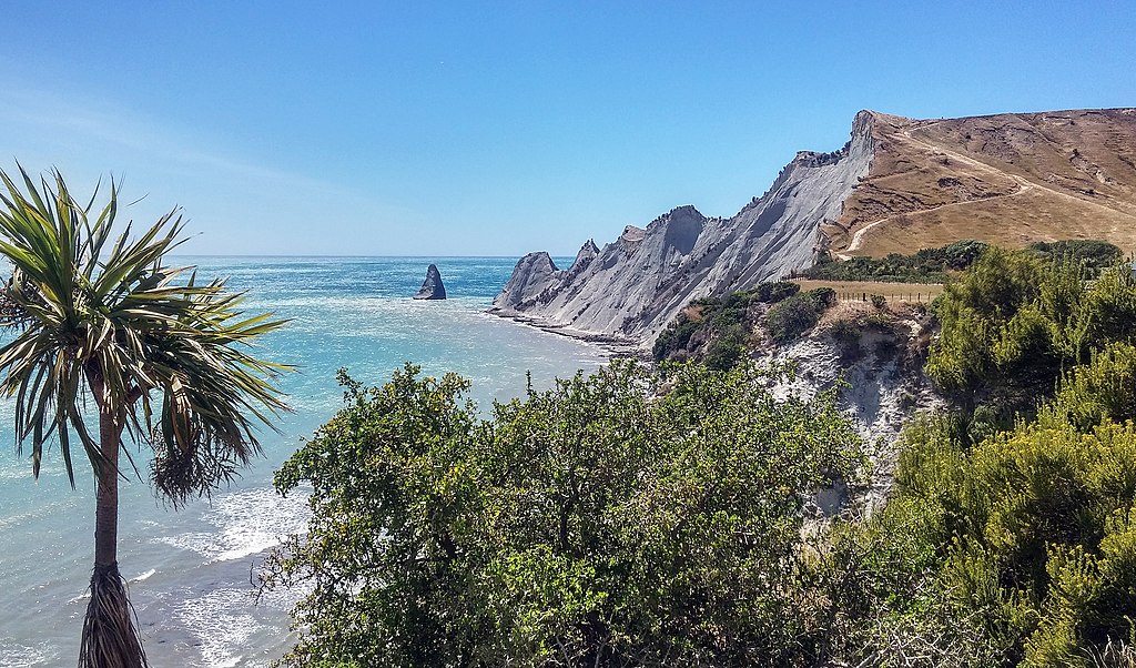
The Department of Conservation (DOC) has today released the risk assessment for landslides and rockfall at Clifton Beach, Cape Kidnappers in Hawke’s Bay.
The Quantitative Risk Assessment (QRA) and Hazard Assessment reports, produced by GNS Science and Stantec respectively, were commissioned by the Hastings District Council (HDC) following a landslide in January 2019 in which two tourists were injured.
The reports state that although the risk levels are similar to some other active landscape areas in New Zealand, they are high compared to the level and type of risk that people would expect to face on an everyday leisure activity.
The SMC asked experts to comment on the findings in the reports.
Professor Tim Davies, University of Canterbury, comments:
“These documents provide an authoritative and detailed picture of the hazards and risks to which Clifton Beach users are exposed. Nevertheless, the information about landslide frequency and magnitude on which they are based is very sparse; data trends from scientific literature are used to supplement local data, so the QRA is unavoidably imprecise. Acknowledging this, the QRA quotes upper and lower bounds for risk-to-life that the data support.
“Given public aversion to recreational death risk, and the consequences of multiple deaths as exemplified by the White Island/Whakaari tragedy, the upper limit risk-to-life figures must be taken seriously. The upper limit of fatality risk is greater than a single death every ten years, or 100 deaths in any given year every thousand years (Fig 4.5, GNS report).
“Although the risks to users of Clifton Beach accessing Cape Kidnappers are stated to be comparable with other New Zealand situations, the upper limit figures are, by international norms, unacceptable by quite a large margin. The only way to reduce the risks is to limit the numbers of people exposed; alternatively, clear and accurate information warning potential users of the risks would allow them to understand the risks and make their own decisions about running them.”
No conflict of interest declared.
Associate Professor Mark Dickson, School of Environment, University of Auckland, comments:
“Both reports use sound methods and are grounded in robust analyses of available data. Stantec conducted two high resolution photogrammetric drone surveys in 2019 showing that more than 100 small landslides (<=100 m3) and five large landslides (>1000 m3) occurred within a five-month period. Hence, landsliding is a very active process in the area that does pose a risk to people on the beach.
“Stantec concludes that the probability of landsliding in this area is ‘judged high, compared to most ‘typical’ sites’ because the area is comprised of eroding coastal cliffs that are both high and steep. As far as I am aware, there has been no nationwide analysis of coastal cliff erosion so it is not yet possible to evaluate the risk to beach users at the base of the Cape Kidnappers cliffs compared to other similar activities at the base of cliffs around the country. In this context, the GNS report provides a useful comparison of the risk associated with visiting the gannets at Cape Kidnappers with many other risks, such as risk of eruption hazards when walking the Tongariro Crossing (without DOC controls), and visiting the Fox and Franz Josef Glaciers (Fig 5.1, GNS report).
“The GNS report makes the point that while the risk levels are not particularly unusual in relation to some other active landscape areas in New Zealand, they are high in comparison with risks associated with other everyday leisure activities for which participants would usually be aware of the risks and warned about. Hence, it does seem appropriate that walkers should be warned of the hazard and be advised on measures to reduce the risk.
“Stantec concludes that coastal processes are important in over-steepening the slopes and comment that ‘it can be assumed the risks would only increase in the future.’ I agree with this conclusion. It is likely along this coast that future higher sea levels will accelerate the over-steepening process leading to more landsliding. It is possible also that beach widths might reduce, meaning that people would be closer to landslides. This increased risk is likely to play out over decades to come (not imminently).
“Although not commented on in the reports, it is worthwhile noting that landsliding in this region is an important natural process that replenishes beach sediment on the coast north of Clifton. Hence, not only is it impractical to prevent cliff erosion, doing so might have unwelcome consequences in terms of reducing the size of beaches that protect coastal communities from erosion and flooding.”
No conflict of interest declared.
Associate Professor Martin Brook, School of Environment, University of Auckland, comments:
“The Cape Kidnappers cliffs accessed from Clifton are spectacular and even a look on Google Earth can indicate how active the slopes are. However, for visiting tourists and day trippers, as we have seen in other parts of New Zealand over the years, the often spectacular, but unstable New Zealand landscapes, can be a fatal magnet.
“On the face of it, the investigations along 9.5 km of cliffs by Stantec and GNS aimed at (1) assessing the landslide hazard and (2) undertaking a quantitative landslide risk assessment, seem a worthwhile exercise. While two tourists were injured on 23 January 2019 by a Cape Kidnappers coastal landslide, in other countries, beach tourists continue to be killed by coastal rock falls from similarly steep, high cliffs, in particular in southwest England’s popular, accessible beaches. Fortunately, according to Stantec, there are only three instances of beach users being struck by a landslide at Cape Kidnappers, in 1973, 1988, and 2019, with no deaths. This is despite Gannet Beach Adventures’ estimate of 500,000 passengers over the last 67 years (recently 12,000/year), in addition to the 15,000 tourists/year that are thought to visit the beach. Intriguingly, in all three instances people appear to have taken evasive action, ran toward the sea, and have only been injured on their lower bodies. Nevertheless, it’s clear from both reports that a range of landslide types and volume magnitudes can occur, from rockfall to rock avalanches. In some places, large, slow-moving planar failures are actively occurring (at probably mm/year), while rockfalls are extremely rapid (meters per second), and avalanches are mobile and may run out large distances from the cliff. Thus, irrespective of the landslide classification system used, there are a myriad of landslide hazards along this coast.
“Now that the hazard (Stantec’s report) and risk (GNS’s report) have been classified and quantified, respectively, what next? In the mining and quarrying industries etc, a hierarchy of hazard management controls are often used, with PPE as the last resort, but preferably the hazard would have been already eliminated, substituted, or engineering controls would be implemented. However, these sites often have in situ geotechnical monitoring equipment, monitoring changes in real-time. How any cost-efficient monitoring programme could be developed for cliffs along a remote coastline with a large seasonality in tourist visitor numbers, is difficult to determine.
“If DOC does re-open their walking path, they may attempt to designate a pathway closer to the ocean, but the beach can be very narrow even at low tide. Moreover, irrespective of any signage or path that DOC implements, some tourists do ignore DOC signage. In January 2009, tourists at Fox Glacier ignored the DOC warning signs and crossed rope barriers to get a photo in front of the terminal ice cliff. I was there with my third year students at the time. The ice cliff collapsed and two tourists (brothers) died. Both tourists were qualified engineers, but had made the choice to ignore DOC warning signs and cross barriers to get a closer look at the ice. DOC signage in the past has been criticised by some for the colour schemes used and the pictograms. However, there is only so much that can be done to manage risk when people make their own choices.
“Perhaps it’s best DOC closes its track, and removes all reference to the walk, save for a large red warning sign about the landslide hazards? While the Quantitative Risk Assessment (QRA) of landslide hazard at Clifton Beach is an interesting scientific exercise, will the improved understanding of slope instability along this remote coastline limit injury and loss of life along the coastline? I suspect not, given only 27,000 annual visitors, who are all moving targets for descending rocks. The elephant in the room is a local source tsunami, which would presumably endanger the lives of anyone on the beach who couldn’t scale a gully quickly enough, which was not the focus of these reports.”
Conflict of interest statement: I recently co-supervised a Master of Engineering Geology student working on coastal cliff failures along the same section of coast. I have worked with some of the GNS scientists involved here.