A campylobacter outbreak in Havelock North affected an estimated 4000 people, sent dozens to the emergency department and sparked an inquiry into what happened and how well the response was managed.

We’ve worked with experts to answer some simple and frequently-asked questions about the water in our aquifers, how it’s linked to surface water, and under what circumstances contamination can occur.
Dr Murray Close, principal scientist
Water, Waste and Social Systems Group
Institute of Environmental Science and Research (ESR)
How does campylobacter make its way into an aquifer up to 20 metres beneath the surface?
“In heavy rainfall or flooded conditions water together with contaminants can rapidly infiltrate through the soil, particularly through any cracks or macropores. In light rainfall the water moves relatively slowly through small pores in the soil and in these conditions bacteria, which are particles, are readily filtered out.
“As the soil becomes more saturated and rainfall is higher intensity then the larger pores are operational, transport is faster and the filtration of bacteria is less efficient. As the soil becomes fully saturated the transport velocity becomes exponentially faster.”
How long can campylobacter survive in an aquifer?
“Less than E. coli which has a half-life of 3.5 days; probably a half-life of about 2 days. For 2 days the half-life concept means that 50% of the number would remain after 2 days; 25% would remain after 4 days; 12.5% would remain after 6 days.
“For a significant contamination event (effluent getting into the aquifer) there could still be quite a lot of campylobacter remaining after a week, depending on groundwater velocities for the aquifer in question. For example, with an alluvial gravel aquifer it could range from 5 to 60 m/day so the campylobacter could travel 50 to 400 m in a week.”
Can it flourish?
“No.”
How easy or difficult is it to find the source of contamination?
“Depends on the number of potential sources. It would probably be within 500 m of the well and almost certainly within 2 km of the well.”
Dr Close also commented on a previous statement about the Walkerton, Canada campylobacter outbreak in 2000.
“This outbreak was a combination of pathogenic E. coli and campylobacter and resulted from a combination of a recent source (cattle manure), rupture of the groundwater confining layer, heavy rainfall and a breakdown of the treatment process.
“A key aspect of whether campylobacter from animal or bird faeces will enter groundwater is the presence of saturated conditions at the ground surface either from heavy rainfall, flooding or heavy irrigation such as flood irrigation.”
Paul White, senior groundwater scientist, GNS Science
How do we know where aquifers are and how much water is in them? Can we measure this directly or is it inferred from other measurements?
“The location of aquifers is interpreted from well logs and geological maps, primarily. Well drillers produce well logs which are a description of rocks that are encountered as a well is drilled. Geological maps describe surface sediments. For example, the location of recent (Holocene) gravels on a geological map is a prime indicator of the presence of a gravel aquifer.
“Water volumes in an aquifer can be calculated using the following:
- volume of the aquifer, calculated as the volume between two 2D surfaces (i.e. the top surface of saturated rock in the aquifer and the bottom surface of the aquifer)
- porosity, which is a measure of the void space in the rock.”
How does water get into aquifers and how long does it take? What makes an aquifer confined or secure?
“The water that gets into aquifers is termed ‘recharge’. This recharge comes from rainfall on the land that lies over the aquifer, rivers, and other aquifers.
“Rainfall recharge occurs where rainfall on the ground soaks into the soil and then flows to an aquifer. River recharge occurs where river water flows into the bed of a river and then flows into an aquifer. Recharge from other aquifers occurs where the other aquifer: is in hydrogeological connection; has larger water pressures; and has a positive water budget, i.e. outflows are larger than inflow.
“An aquifer is confined where the groundwater pressure in the aquifer is higher than ground level (a flowing artesian aquifer) or is higher the top of the aquifer, but below ground level (a subartesian aquifer).
“Aquifer security is defined by the Ministry of Health. This includes protocols for water testing and monitoring. In addition, groundwater age measurements are now commonly applied to assess compliance with drinking-water standards (Ministry of Health, 2008).”
How do we know how old the water in aquifers is? How does that relate to drinking water standards?
“Groundwater age measurements are one technique to assess the age of groundwater. These measurements include gases (e.g. CFC) tritium (a Hydrogen isotope) and C14 (for older groundwater. Other techniques to age water also include groundwater flow modelling and groundwater chemistry.
“Groundwater age is one technique used to assess bore security.”
How are surface waters connected to groundwater and how long does it take for surface water to reach aquifers?
“Surface waters are connected to groundwater through the shallow geology where that geology is permeable. For example rainfall recharge flow to groundwater through shallow gravel aquifers and river recharge will flow from the river bed into shallow gravel aquifers .
“Surface water recharge can occur over a wide range in time scales. For example:
- rainfall recharge to groundwater through shallow gravel aquifers can occur almost instantaneously as demonstrated by rainfall recharge measurement sites In New Zealand
- rainfall recharge typically takes months to reach groundwater in the Taupo Volcanic zone
- rainfall recharge can take millennia to reach groundwater in Australia.”
What effect do extreme events – e.g. drought, heavy rainfall – have on aquifers? Does it affect how quickly they recharge and the risk of contamination?
“Drought typically reduces groundwater levels as aquifer storage reduces during the event. Heavy rainfall typically increases groundwater levels and increases groundwater storage. However, heavy rainfall events in summer may not result in rainfall recharge where the soils are very dry before the event.
“Generally, little, or no, rainfall recharge to groundwater is measured in aquifers located on the east coasts of the North Island and South Island. Generally, most rainfall recharge to aquifers located in the east coasts of the North Island and South Island occurs in winter. Therefore, the risk of contamination to groundwater, associated with rainfall recharge, is larger in winter.”
An earlier version of this page mistakenly attributed Paul White as a Dr. He is a senior groundwater scientist at GNS Science and has published extensively on groundwater resources in New Zealand.
Dr Helen Rutter, senior hydrogeologist, Aqualinc Research Limited
What is an aquifer, a bore and a well?
“An aquifer is a body of saturated, permeable rock or sediments which contains groundwater. They can be hard rocks, such as limestones or basalts, where groundwater moves through fractures or cracks, or unconsolidated gravels and sands, where water moves through the pore spaces between particles.
“A bore is a hole that is drilled into an aquifer, and normally lined with a steel or PVC casing. A well is often taken to be a completed bore, set up with a screen and pump to abstract groundwater for use. However, in New Zealand the terms ‘bore’ and ‘well’ are often used interchangeably. A completed well must have a secure well-head. This means that the casing at the surface must be properly sealed, to provide protection from surface contamination getting into the well or down the outside of the casing into the aquifer.”
How do we know where aquifers are and how much water is in them?
“Initially, aquifers are identified through geological mapping of the subsurface materials, as wells are drilled the extent and properties of the aquifers are continually refined. After drilling a well, testing is often carried out to determine how much water can be abstracted and at what rate: this, adds to our understanding of the aquifer system as a whole. New Zealand aquifers and their boundaries were identified in research by Geological and Nuclear Science published in 2001, and updated last year with information provided by regional councils. Aquifers can be three-dimensional, and in a ‘multi-layered’ aquifer system, different aquifers occur stacked up at different depths in the same location.”
What are confined/unconfined aquifers?
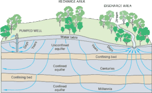
“The aquifer is considered confined, at a location, if there is a layer of fairly impermeable material, like clay, which overlays and seals the aquifer. At this location, it forms a closed ‘reservoir’ of water held within spaces in the rock or sediment. In this case, it is more difficult for any surface contamination to enter the aquifer, and water that comes into the aquifer is often sourced some distance away.
“Unconfined aquifers do not have the top protective layer, and recharge from the land surface can move down through the unsaturated zone and until it reaches the top of the aquifer, which is known as the water table. The unsaturated zone varies in thickness from one area to another. If there is a thin unsaturated zone, then contamination that leaches from the surface layers may get to the water table rapidly. Once in the saturated zone, any contaminants may be transported rapidly in the groundwater. Although unconfined aquifers can yield safe water, there can be situations where there are increased risks, for example in shallow gravel aquifers overlain by shallow soils.”
How do contaminants get into groundwater?
“The potential for groundwater contamination to occur is complex and determined by: 1) how much contaminant there is, 2) the rate at which it is being leached downwards 3) how long will it take to get to the water table i.e. how thick is the unsaturated zone, 4) where the contaminant enters the aquifer system, 5) the aquifer vulnerability – that is the properties of the unsaturated zone 5) how fast the water is moving in the aquifer and 6) removal capacity of the aquifer.
“From the land surface, pathogens will be transported through the soils and sediments by recharge. In many systems, this is relatively slow flow, and pathogens may die off or be reduced in concentration before they can migrate to any significant depth. However, this is a function of the type of soil and sediments and rate of recharge. For example, if there is a pathway or crack for rapid flow of water (bypass flow) then they can quickly be transported to depth. These rapid pathways might be formed through natural conditions, such as old root channels, high permeable pathways or cracks, or through artificially created pathways, such as old wells that do not have a protected wellhead, or are open.
“There are also some sources of contaminants that bypass the soils and shallow sub-surface, such as septic tanks or faulty sewers, which, if they leak, have a more rapid pathway to access groundwater.”
How are surface waters connected to groundwater? What might lead to contamination from surface water?
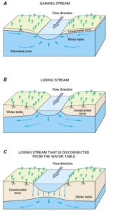
“Surface water and groundwater are normally closely connected – for example, if there hasn’t been recent rainfall, the flow in the stream is from groundwater. In some cases, groundwater moves into surface water (a ‘gaining’ stream), and in other cases, the movement is in the opposite direction, where the stream or river is said to be ‘losing’ to groundwater.
“Connections between groundwater and surface waters can be very direct in some cases. An example would be a shallow well located on a riverbank: the water taken from the well would be almost entirely river water. Deeper wells and those located further away from surface waters would be likely to have a less direct connection with the surface water and more of the water is from land surface recharge. In some cases, we can monitor a stream when pumping groundwater from a well, and observe a change in flow in the stream. This implies a close connection between surface water and groundwater.”
What effect does drought have on recharge? What are the water quality implications?
“Recharge usually occurs during winter months, when the soils are close to being saturated, temperatures are low, and there is little soil evaporation or transpiration from plants. If there is a lack of winter rainfall, then recharge to groundwater will be limited. We have seen this in Canterbury over the past three years.
“The result is that groundwater levels decline. With limited recharge, there is also limited capacity for the leaching of nutrients. However, when a recharge pulse does occur, this can transport nutrients, such as nitrate, along with water down to the water table. Although we might expect to see a spike in nitrate level, there should be a lower risk of pathogens as many would have died off.”
Is it generally safe to assume that secure aquifers are safe to drink? Are the situations when that assumption is not the case (i.e. drought, heavy rainfall)?
“The Drinking Water Standards for New Zealand (2005, Revised 2008) have detailed specifications in regard to bacterial compliance criteria. In the standards, E. Coli is used as the indicator organism for contamination of water by faecal material: the presence of E. Coli in a sample indicate that contamination has occurred and that other pathogens may be present.
“The standards provide a definition of a “secure” groundwater source or well, that is, one that should NOT have the potential to be contaminated by faecal contaminants, as there is no evidence of a direct connection with a source of contamination. The standards define a secure source as one where: it can be demonstrated that the water is the well is not directly affected by surface or climate influences, as defined by certain criteria. These include:
- the chemical composition and age of the water, and lack of detected E. Coli in samples, as specified by the sampling regime set in the drinking water standards and
- it has a secure, protected well-head
“If a secure source has detections of E Coli, then it has to be sampled much more rigorously until it is proved to be secure again.
“As a consequence, ‘secure’ wells should have good quality water (in terms of pathogens) and should provide water that is safe to drink. However, it is possible to envisage that things can go wrong – under intense storms, for example, water that has accumulated at the surface, might result in more rapid infiltration of water through the unsaturated zone, or surface runoff might find its way down an old, unsecure well that hasn’t been capped or sealed at the surface.”