For the first time, scientists have watched a slow-motion earthquake unfold below the sea, offering insights into the earthquake and tsunami risk New Zealand faces.
 A new study, published in the leading journal Science, reports on the Hikurangi Ocean Bottom Investigation of Tremor and Slow Slip (HOBITSS) experiment.
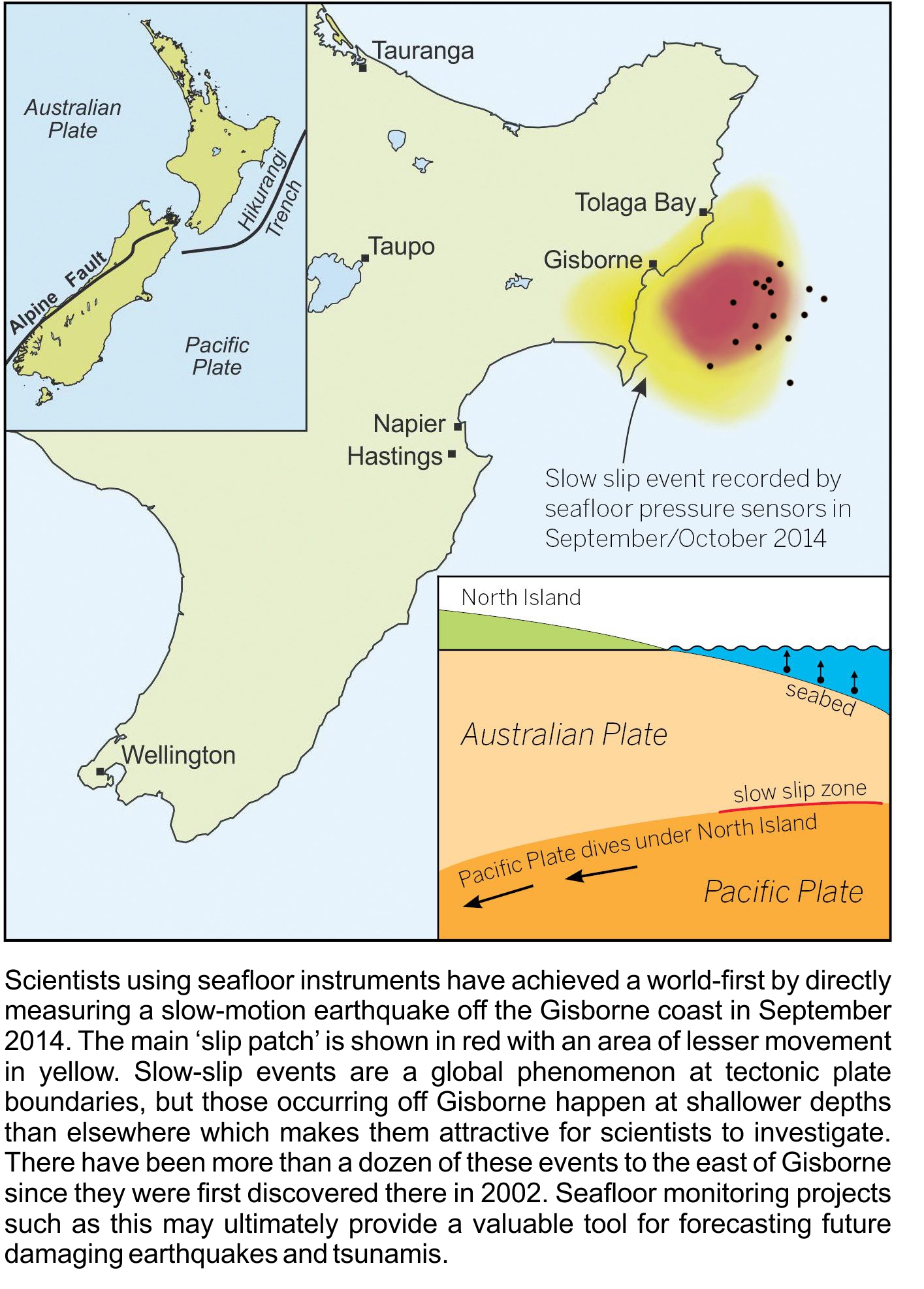
Two dozen sensors deployed along the seafloor off the coast of Gisbourne in 2014 picked up a ‘slow slip’ quake lasting two weeks, resulting in 15-20 centimetres of movement – equivalent to three to four years’ worth of steady plate motion.
The extent of slow slip can indicate how much stress on the plate boundary fault is relieved versus building up toward an eventual megathrust earthquake. The authors say the data gathered from this research and future monitoring projects is vital to build up knowledge of the relationship between slow-slip events, megathrust earthquakes, and tsunamis globally.
Earthquakes are unpredictable events, says Laura Wallace, a research scientist at The University of Texas at Austin’s Institute for Geophysics who led the study, but the linkage between slow-slip events and earthquakes could eventually help in forecasting the likelihood of damaging earthquakes.
“To do that we will have to understand the links between slow-slip events and earthquakes much better than we currently do,” Wallace says.
Read more about the research on Scimex.org.
The SMC collected the following expert commentary.
Dr Stuart Henrys, geophysicist at GNS Science, was an author on the study. He comments:
Has our understanding of the earthquake and tsunami risk posed by the Hikurangi subduction zone changed?
“The prevailing view of megathrust earthquakes occurrence dictates that subduction interplate faults slowly and steadily accumulate stress from tectonic forces until a threshold is overcome and then fail in a large “felt” earthquake. Traditional efforts to forecast earthquakes are based around this simple model. We now know that faults don’t behave that way and non-traditional earthquakes (like slow-slip) occur throughout the earthquake cycle, leading to more complex patterns of stress accumulation that potentially can alter the strength of the interplate faults to shallow depths beneath the seafloor. Understanding and monitoring the time changes of this system may provide a valuable tool to forecast future damaging earthquakes.
What’s next? What new questions does this research raise?
“There are a number of next steps:
1) We have successfully detected slow-slip offshore through one repeating cycle and we need to improve the accuracy and reliability of instruments through multiple cycles of slow-slip. We will do that by combining our seafloor observations with placing instruments in boreholes in 2018 when we undertake International Ocean Discovery Programme (IODP) drilling.
2) So far we have detected shallow slow-slip offshore Gisborne and would like to now determine if other parts of the offshore East Coast deform in the same way. In June this year we will deploy 4 instruments offshore Hawke’s Bay for this purpose but urgently need to build the capacity in NZ to be able to extend the GeoNet network of instruments offshore.
3) Finally, we want to test if slow-slip deformation can rapidly change stresses on the subduction interface and if those changes can be detected with current instrumentation and observations. Seismologist Dr Bill Fry of GNS Science was awarded a Marsden Fund grant last year to further this research.”
Dr Virginia Toy, Geology Department, University of Otago, comments:
“Publication of this study is very important for understanding EQ risk from the Hikurangi Subduction Zone. It demonstrates that at least a part of the built up elastic strain at this margin is not released in Earthquakes, but instead in slow slip events that won’t generate significant ground shaking. I am not saying that earthquakes that shake the ground aren’t still possible though! However, I do think that recognition such slow slip events are possible is good news for earthquake hazard predictions, and this new information will definitely allow us to build more realistic hazard scenarios.
“Note that there are also implications for understanding tsunami hazard. These sort of events shouldn’t generate tsunami by direct displacement of the ocean floor, but those slow displacements might still cause submarine landslides that will cause tsunami.”
Assoc Prof John Townend, Director, EQC Programme in Seismology and Fault Mechanics, Victoria University of Wellington, comments:
Are the findings important?
“Yes — this study reveals for the first time that slip taking place offshore from Gisborne on the main subduction fault (Australia-Pacific plate boundary) extends to within 2 km of the seabed, where temperatures and pressures are low. Understanding how fault slip can occur at such shallow depths and such low temperatures and pressures is important for understanding how large subduction zone earthquakes occur and how they generate damaging tsunami.”
What is the Hikurangi subduction zone?
“The Hikurangi subduction zone is the geologic boundary between the Pacific and Australian tectonic plates off the east coast of the North Island. The Pacific plate is being thrust westward beneath the Australian plate at a rate, averaged over long time perioda, of ~3-6 cm/year. The interface between the two plates is referred to as a “fault” or “subduction thrust”. The two sides of the fault slip past each other during earthquakes. The fault also slips more slowly (over weeks or months) in a process known as “slow slip”.
What did this study involve?
“The New Zealand–US-Japanese research team used ships to install pressure gauges on the seabed east of Gisborne. Based on previous on-land GPS measurements, the researchers expected the subduction fault to slip sometime during the one-year deployment, and it did. As the fault slipped, it caused the seabed to rise by several centimetres over a 2–3-week period. A computer model was used to calculate how much slip had occurred, and where. If the slip had occurred abruptly as in a regular earthquake, it would have had a magnitude of approximately 6.8.”
Why has this research been conducted near Gisborne?
“It has been known for about a decade that portions of the Hikurangi subduction zone east of Gisborne, where the Pacific Plate slides beneath the Australian Plate, occasionally slip by several 10s of centimetres over periods of days to weeks. This process is known as “slow slip”. The same area of the plate boundary also produces tsunami-generating earthquakes (most recently in March 1947). The research team is working to understand what the physical conditions (temperatures, stresses, pressures) are in which earthquakes nucleate. The area of Gisborne is internationally significant because the slip appears to take place at very shallow depths, potentially within the reach of scientific drilling equipment. This study is part of a much larger effort to understand how earthquakes are generated along the eastern coast of the North Island and in similar settings elsewhere.”
What future research is planned?
“The members of this research team are involved in a larger study aimed at installing permanent monitoring equipment beneath the seabed east of Gisborne, using scientific drilling ships to install instruments that measure fluid pressure, temperature, fluid chemistry, and seismic waves. The results published here will be used to target future drilling and other surveys. Additional surveys using seabed pressure gauges and seismometers will be conducted in coming years, with the next deployment scheduled to take place in June 2016.”
How do these results affect our understanding of earthquake and tsunami hazard?
“The results published in this study reveal that slow fault slip can occur at depths as shallow as ~2 km beneath the seabed. Parts of the fault also slipped, much more rapidly, in the March 1947 earthquake that produced a damaging tsunami. The new results will enable seismologists to better understand what factors control fault slip and the generation of tsunami. The Tohoku earthquake in northeastern Japan in March 2011 and the tsunami that followed were particularly damaging, in part, because the fault slipped right to the seabed. Understanding whether that could occur east of the North Island will provide valuable information for hazard assessment.”
Dr Willem de Lange, Senior Lecturer, Earth Sciences, University of Waikato, comments:
“These findings are important – slow slip events are an important processes for releasing stress at plate boundaries. They cause relatively slow displacements of the land, which are too slow to generate tsunamis, but can cause significant changes to relative sea level. For example, analysis of variations in the rate of sea level rise at Wellington, indicate that slow slip events can significantly increase the rate of sea level rise (albeit temporarily) as the shoreline subsides in response. Similar behaviour may also have occurred before the 2004 Banda Aceh and 2011 Tohuku earthquakes, where shoreline subsidence was followed by rapid uplift during megathrust subduction earthquakes (with catastrophic tsunamis being generated).
“The measured events off Poverty Bay may indicate an increasing potential for a major tsunami in the future. In particular, the data reported in this study indicate that the source area for significant tsunamis in 1947 (and possibly 1926) experienced less slip than the adjacent plate boundaries, suggesting stress may be accumulating in that area.
“It would be interesting to see if there is a link between the slow slip events and unusual phenomena such as the aseismic Sponge Bay uplift that occurred near Gisborne in February 1931.”