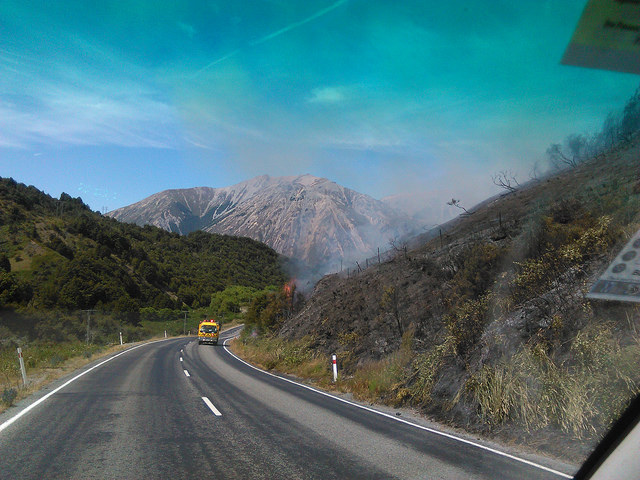
Experts say that the fire that destroyed around 300 hectares of forest and tussock at the Flock Hill Station in Canterbury, was exacerbated by dry, windy conditions and difficult terrain – but could have been much worse had the weather not changed yesterday.
The blaze, which started on Monday afternoon, has been the focus of firefighting efforts on the ground and using water drops by helicopters and fixed-wing aircraft from the air.
Cooler, moister conditions and lighter winds yesterday and today helped prevent the fire spreading further and threatening Cave Stream Reserve and Castle Hill Village.
You can read more in updates on Department of Conservation website.
What are the conditions that lead to wildfires and the barriers to the firefighters battling them?
The SMC collected the following expert commentary from a Scion wildfire researcher who was at the scene. Feel free to use these quotes in your reporting. If you would like to contact a New Zealand expert, please contact the SMC (04 499 5476; smc@sciencemediacentre.co.nz).
Grant Pearce, Scientist, Fire Research, Scion, comments:
“The dry drought-like conditions prevailing at present have definitely contributed to the extreme risk across Canterbury and others parts of the country, and to the outbreak and spread of this particular fire. Although starting along the roadside, the Flock Hill fire spread through dry grass and scrub vegetation into heavier fuels of wilding pines and beech forest. These forest fuels require very dry conditions to dry out the larger woody materials and deep soil organic layers, so that these types of fires usually only occur every few years or decades. (The last time similar conditions occurred in Canterbury was during the 2003/04 fire season, when a number of significant wildfires also occurred).
“The very dry conditions and availability of the larger woody material and soil organic layers also contribute to deeper burning. As a result, fires smoulder for longer and are harder to fully extinguish, requiring prolonged and arduous “mop-up” by ground crews. Smouldering fires also have greater potential to flare-up again at a later time if another wind event (such as a nor’wester) occurs a few days or even weeks later. For this reason, farmers, etc. are being restricted from burning (especially heavy fuels such as slash piles, e.g. from previous wind-blown trees, land clearing or hedge trimmings, etc.) through fire authority restrictions or total fire bans, many of which are in place across the country at present.
“The hot, dry windy conditions on Monday helped spread the Flock Hill fire, and combined with the steep slopes and heavy fuels, including areas of previously sprayed dead-standing wildings, contributed to very high intensity crown fire behaviour that was difficult if not impossible to control, even with the large numbers of helicopters and fixed-wing water bombers at the scene. Burning embers were being transported considerable distances (500-600 m) ahead of the main fire, starting new fires and causing erratic fire spread.
“These severe conditions continued into the earlier hours of Tuesday morning, when downslope spread and a change in wind direction from the west to more benign southwesterlies, helped slow the spread of the fire. Cooler, moister conditions with only light winds on Tuesday (and today) have helped the fire operations contain the fire to the extent it had reached yesterday morning. Had the strong westerlies winds continued, the fire had the potential to spread much further to the south, threatening Cave Stream Reserve and possibly also to Castle Hill Village, for which an evacuation plan had been prepared.
“Factors which made this fire very difficult to control were:
- hot, dry (and windy) conditions, with high temperatures (low 30s degC) and low humidity <30%), which also contributed to very easy fire ignition
- strong gusty northwesterly winds, and changeable wind directions, which contributed to rapid and erratic fire spread
- steep, complex terrain, which also caused erratic fire spread, with rapid uphill fire runs and slower downslope spread and “fingering” of fire spread in different directions
- mixed fine flashy (scrub and grass) and heavier forested (wilding and beech) fuels, especially areas of sprayed dead, standing wildings, which contributed to rapid fire spread and “spotting” from burning embers
- underlying drought conditions making heavier forest fuels and deep soil layers available to burn, and contributing to high fuels loads and increased fire intensities (larger flames)
- the deep burning resulting from the dry conditions contributing to extended smouldering, and flare-ups in increased winds
- difficult terrain, lack of access, erratic fire spread and nighttime conditions making it unsafe to use ground resources during the peak of the fire
- lack of vehicle tracks to provide ground access for firefighting crews, meaning initial attack was almost solely restricted to use of aircraft
“Although lower than normal due to the dry conditions, water sources were not a limiting factor in this case, as there were numerous small streams across the area from which water could be pumped into portable dams for filling monsoon buckets. The fire was also relatively close to Lake Pearson, from which helicopters could dip directly, and water pumped into tankers to fill the fixed-wing aircraft. The flat paddocks immediately adjacent to the lake also made this an excellent airstrip for operating aircraft out of.
“On a related note, the occurrence of this fire in wilding conifer fuels was of particular interest from a research perspective. Scion’s rural fire research team has been undertaking research into the fire hazard associated with wildings, as existing fire behaviour prediction models do not do a good job of estimating fire spread rates and fuel loads in this fuel type. We are planning to conduct a series of burn experiments in the next few months to collect data on this, particularly the comparison of fire behaviour in sprayed versus untreated wilding stands. These burns will be conducted near Twizel with the support of local fire authorities, with timing dependent on fire danger conditions over the next month or so. If the dry conditions continue, as it sounds like they may well do, then the burns are likely to be delayed.”