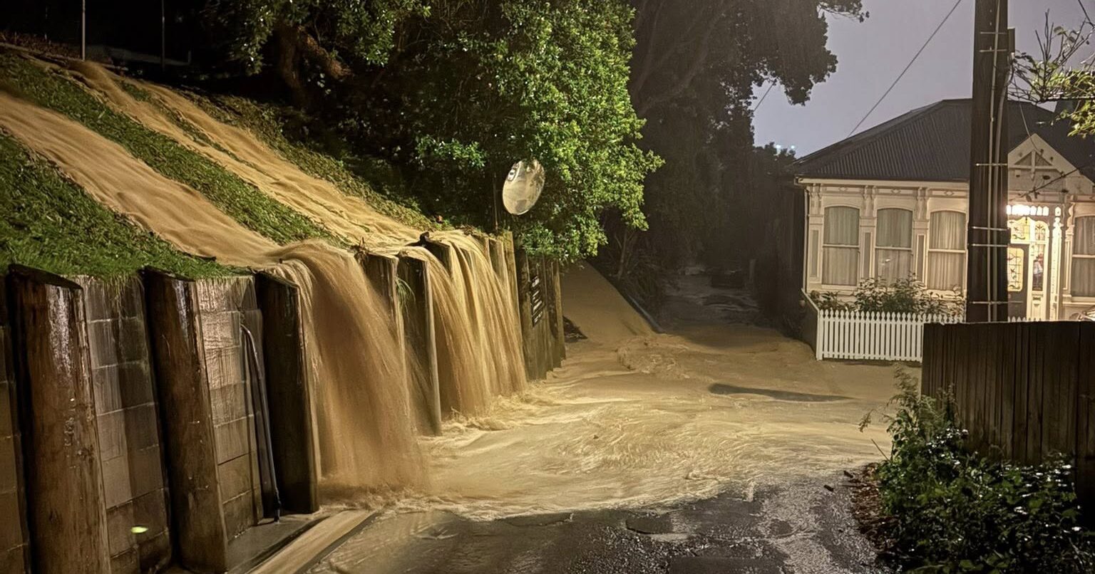
A state of emergency has been declared in Wellington, as torrential localised downpours flood suburbs with little warning.
Other areas across the North Island have also been affected, with more rain expected until Tuesday night.
The SMC asked experts to comment on:
- Flood warnings
- Flood science
- Landslides
- Cleaning up mould
- Sewage discharge at Moa Point
- Climate change
- Building flood resilience
- More rain still to come
Flood warnings
Dr Sally Potter, social scientist and warnings consultant, Director of Canary Innovation Ltd., comments:
“My thoughts are with anyone who has to clean up floodwater and silt following these severe weather events around the country. Having had to do this myself over the weekend with the localised downpours in Tauranga, I feel your pain.
“It is difficult for forecasters to know exactly where localised downpours, thunderstorms, and tornadoes will occur before they happen – the science just isn’t there yet. This means that we can’t get specific warnings for these events hours in advance. This is different to more broadscale events, such as Cyclone Vaianu, where days of warning can be given.
“What you can do is always store items that are important to you off the floor, and in watertight containers. Then if you are surprised by a flood, you have a better chance at keeping those items safe.
“You can keep an eye on the forecasts, particularly for words like ‘localised’, ‘thunderstorms’, and ‘downpours’. If these are in the mix, then they can occur anywhere in the area. They may hit you or someone else across the region, so it’s best to get prepared if you can, just in case. In these situations, you can do things like have your grab bag ready, park your car on higher ground if possible, lift rugs off the floor, and prepare for keeping your animals safe.
“There may only be time for natural warning signs, rather than official warnings. Remember to keep an eye out for any signs of landslides due to all this rain – things like small slips that can lead to bigger landslides, fences and walls tilting away, new cracks or bulges on the ground or retaining walls. If you see any of these signs, evacuate, and tell neighbours, emergency services, and your local council.”
Conflict of interest statement: “None.”
Dr Lauren Vinnell, Senior Lecturer of Emergency Management, Joint Centre for Disaster Research, Massey University, comments:
“It’s been a tough night for many Wellingtonians, with more rain on the way.
“It’s important to keep an eye on your surroundings and if you think you’re in danger, act immediately. If you feel unsafe, arrange to stay with family or friends or head to an evacuation shelter. Landslides and floodwaters can be very dangerous, so stay away if you can. Download the Metservice app, listen to RNZ, and find your local emergency management group online to stay up-to-date.
“Despite best efforts, weather is never completely predictable. Sometimes it gets worse very suddenly, like we saw with the recent flooding in the Wellington region, and sometimes it changes track, like we saw with Cyclone Vaianu.
“It’s understandable if some Wellingtonians are a bit frustrated after these floods happened with little warning, especially after being told to prepare for the cyclone which ended up missing us. We were lucky to not experience the kinds of effects that were seen up north, so those who acted on the warnings for the cyclone did the right thing. Consider it as great practice so that next time there’s an event, with or without official warnings, you’re able to respond quickly and confidently. We know that having practice in what to do during an emergency helps you to be less scared and make better decisions when you’re in danger.
“It is important that we take official warnings seriously when we do get them, and that we do what we can to have a resilient warning system. But we also need to continue the great work being done to teach natural warning signs and how to respond because sometimes there just isn’t time to send an official warning.
“There are also bigger challenges we need to address. Severe weather events are not going anywhere, so we should do what we can to reduce their impacts. For example, making better decisions about where and how we build, making sure that choices we make during recovery from one disaster will make the next one less bad, and doing our part to limit contributions to climate change.
“There’s probably a lot of people feeling stressed, anxious, or scared, especially in parts of the country which have been hit multiple times. One of the best ways to manage these feelings is to do what you can to get more prepared. There’s also places you can go for help and advice around looking after your mental health.”
Note: This comment has been updated with more on flood warnings.
Conflict of interest statement: “No real or perceived conflicts of interest to declare.”
Dr Nathanael Melia, Founding Director at Climate Prescience Limited & Adjunct Senior Research Fellow at Victoria University of Wellington, comments:
“The science is not the main problem here. New Zealand’s problem is that we have not invested enough in the operational forecasting infrastructure needed to resolve these kinds of intense, local rainfall events.
“With high enough resolution, enough ensemble members, enough observations, and strong data assimilation, these events are forecastable in the sub 24 hour window. What has been lacking is not the underlying physics, but the legacy investment and system architecture needed to turn physical meteorology into public warning capability.
“Hopefully the changes to the New Zealand weather forecasting system (merging MetService and NIWA) will solve much of these issues, I just wish it would hurry up.”
Conflict of interest statement: “Dr Nathanael Melia advised the Government’s Weather Forecasting System Review and submitted to the Meteorological Services (Acquisition and Policies) Legislation Amendment Bill following Parliamentary invitation.”
Flood science
Dr Emily Lane, Chief Scientist, Flooding, Extreme Weather and Space Hazards, Earth Sciences NZ, comments:
“The intense rainfall over the past few days has caused what’s known as pluvial flooding. Cities, such as Wellington, tend to have a high proportion of impermeable surfaces where water can’t soak into the ground. Instead the water relies on stormwater systems to dissipate. But when the quantity of water is more than a stormwater system can handle, the excess water will follow overland paths to flow towards the sea.
“Unfortunately, short and relatively localised but very intense events like those we’ve seen over the past few days are the type of event expected to increase the most with climate change. One-hour duration, 1% AEP (sometimes called one-in-100-year) maximum rainfall is expected to increase by around 14% for every additional degree of warming to our climate.
“While the most recent event has occurred in Wellington, these intense rainfall events could happen anywhere around the motu. Places that are more vulnerable tend to be those with more impermeable surfaces, areas where overland flow paths converge or low lying areas where water can’t drain easily.
“Regional councils are thinking about how to design urban environments to better handle flooding and this can involve things like making room for rivers and ensuring more permeable surfaces, such as designing “sponge cities”. In the shorter term, anything that can help water flow more freely, like keeping drains and gutters cleared, can help.
“As with all flood events, we recommend people follow advice from the National Emergency Management Agency and their local Civil Defence organisation. This includes putting safety first and not taking any chances. Floods and particularly flash floods due to overwhelmed stormwater systems can happen fast – act quickly if you see rising water and don’t wait for official warnings. It’s also important not to enter flood water. Among other hazards, overwhelmed stormwater systems can result in popping up of manhole covers, which you might not be able to see because of the silt in the water.
“Our thoughts are with those impacted by these latest events.”
Conflict of interest statement: “No conflict of interest to declare.”
Emeritus Professor Eric Pawson, School of Earth and Environment, University of Canterbury, comments:
“We’ve known for decades about the potential for urban flooding issues: Neil Ericksen drew attention to this in his report called “Creating Flood Disasters?” for the Ministry of Works in 1986. But the ministry was abolished shortly after and many of his recommendations have never been implemented.
“That said, the issue is clearly becoming more urgent with unpredictable storms due to climate change (which really means greater patterns of disturbance in a heating atmosphere). It’s hard to predict which way storms will track, but what’s becoming clear is that we’re seeing more and more examples of storms that are slow moving or stall: like Cyclone Gabrielle in 2023, the Valencia floods in Spain in October 2024, and the Texas floods that swept through the children’s camp in July 2025.
“How else to account for a storm that drops 77mm of rain in an hour? But whilst it is not possible to say where or when such events might occur next, it’s becoming increasingly urgent to address questions of mitigation and adaptation nationally so that we have some sort of policy framework that seeks to minimise harm and works out who pays.”
Conflict of interest statement: “No known conflicts of interest.”
Landslides
Dr Kerry Leith, Engineering Geologist, Earth Sciences NZ, comments:
“There’s a really good chance of more slips occurring in Wellington, and there’s three reasons for that.
“One is that the rain we’ve seen is really intense for the region, and this is likely to trigger more localized landslips like we saw last night.
“Secondly, the hill slopes are already wet after the rainfall that we’ve had today, so additional rain is just going to load up those hill slopes and has the potential to trigger things that didn’t fail last night.
“And thirdly, there’s the impact of damage to infrastructure from creeping landslides. These slips might just start to move a little bit day by day. That might damage infrastructure – for example, retaining walls or stormwater pipes or footpaths that are channeling flow. That damage can accumulate over time, so we might see more water entering hill slopes because of the damage.
“Here’s how to watch out for a landslide. Typically, when we’re at home, we might see doors or windows can get stuck, or parts of the house can start to creak. There might be cracks opening up in the gardens or in the lawns, you might see just a little bit of debris start to come down. Often, bigger landslides start with just very small slips. So if you do see any small debris coming down from a hill slope, be really aware that there might be something bigger pushing it. Also any water, springs, or mud flows that come out of a hill slope can be an indication that the slope is really saturated and might fail at some point.
“So if you see any of these key triggers, and it’s a good idea to get out and find somebody who knows what they’re doing to come and have a look.”
Conflict of interest statement: No declaration received.
Cleaning up mould
Dr Mikael Boulic, Senior Lecturer, School of Built Environment, Massey University, comments:
“Mould spores are everywhere; now that flooding has brought the water, the mould will need food to grow. Materials we find around our house, like wooden surfaces, paper and books, cardboard, curtains, and fabric, can be a good source of food for mould.
“The key sentence is “Dry as quick as possible to avoid mould from starting to grow!”
- Ventilate as much as possible,
- Use a dehumidifier (professional ones are much more powerful)
- Heaters could also help in drying out
“What to do if you spot mould patches? If you find some small mould patches, you can clean them with a solution of 70% white vinegar and 30% water instead of harsh chemicals. However, mould will return if moisture persists, so it’s crucial to eliminate dampness to solve the problem.
“If you have extensive mould patches, it is safe to ask advice from mould experts. Warm, dry and mould-free homes are crucial for your family’s well-being.”
Note: Dr Boulic and other experts have previously commented on making homes safe after flooding.
Conflict of interest statement: No declaration received.
Sewage discharge at Moa Point
Professor James J. Bell, Professor of Marine Biology, Victoria University of Wellington, comments:
“The continuous offshore discharges of raw untreated sewage and the regular release of completely unfiltered sewage close to the shore during these large rainfall events is extremely disappointing and Wellington needs this issue to be fixed.
“Heading into winter we will see greater rainfall and likely an increased frequency in the use of the short outfall pipe which releases discharges that include sanitary products, wipes and other plastic products. Because of the ongoing contamination of the water it’s still not been possible for us to assess any potential impacts on the marine communities, but the longer this continues the more likely there will be impacts.
“I also express sympathy for the many people whose homes are flooded and people who are adversely affected by these heavy rains.”
Conflict of interest statement: No declaration received.
Dr Christopher Cornwall, Senior Lecturer in Marine Biology, Victoria University of Wellington, comments:
“The continued discharge of untreated sewage is not ideal. It will have adverse impacts on the marine ecosystems on the south coast, such as the biodiverse and productive kelp forest ecosystems near the Tarakena Bay/Moa point spill region. The outflow adds anthropogenic nitrogen, particles that influence light quality, as well as contaminants such as microplastics into the water. The longer the outflow is dumping untreated sewage, the more likely there will be of an adverse impact.
“We know that when similar events occurred in San Diego in the 1950s and 60s that large areas of kelp forest died. While we have not observed that so far, it is likely that seaweeds in the area will be ging to take up this source of nitrogen and the natural balance in the ecosystem will shift towards species that take advantage of added nitrogen, such as green tide forming Ulva seaweeds.
“It is unknown to what extent the microbiome (i.e. microbes) on or in marine organisms have been influenced by this outflow and previous ones. We see fewer large brown canopy forming seaweeds (such as kelp) in other areas in the Wellington region near long term outflows, and it is likely this could occur here too. This means less food and habitat for many species we like to eat, such as pāua and many fin fish. We also do not know whether pāua and kelp will be impacted around Tarakena Bay in the long term future.”
Conflict of interest statement: “I receive funding from the Tertiary Education Commission, MBIE, Greater Wellington Regional Council and Centreport.”
Climate change
James Renwick, Professor of Climate Science, Victoria University of Wellington, comments:
“The flooding in Wellington over the weekend is shocking in its intensity, so much damage and disruption happening so quickly, an absolute nightmare for those affected.
“The Mayor reported that 77 mm of rain fell in one hour at one location, a level of rainfall that is truly tropical and would be extreme even in the tropics.
“We are again seeing the effects of adding moisture to the air, which happens as that air warms. More moisture equals heavier rain, and can lead to more intense thunderstorms that draw in even more moisture to deliver the kind of deluges we saw this weekend.
“The only way to stop such events becoming more extreme is to stop adding greenhouse gases to the air, especially carbon dioxide from fossil fuel burning. Anything our government, and all governments, can do to move away from fossil energy is something we would all be thankful for.
“In the meantime, we must all adapt as best we can.”
Conflict of interest statement: “I have received government funding for climate change research, through MBIE and the Royal Society Te Aparangi.”
Building flood resilience
Dr Kathryn Stokes, Senior Materials Scientist at Building Research New Zealand, comments:
“The storms over the last couple of days have reminded us of the risks of flash flooding. How water will behave around the built environment in heavy downpours can be unpredictable. Stokes Valley, where I live, experienced some of the worst flooding over the weekend, which was quite different to the significant storm we experienced in mid Feb. This time, the water levels vastly exceeded the capacity of stormwater system and it happened quickly (~30 min). This combined with increased development in those areas which reduce the permeable surfaces results in the water having nowhere to go but on to roads and into peoples’ homes.
“For homeowners this is a concern. But there are things households or communities can do. By identifying where water is pooling during heavy rain now and looking to increase permeable surfaces for water to drain away around your property and working with neighbours to remove blockades to storm water drains, you can improve the resilience of your property for future storms.
“If you can identify flow paths during heavy rain, you can try to keep them clear and alert your local council if the drainage system is being overwhelmed. Silt and loose fill can easily cause drain blockages and needs to be cleared.
“Right now, for those affected the most important thing once it is safe to go in, take lots of photos and video and get wet things out. It is vital that properties can dry as soon as is possible to ensure their homes stay healthy in the future. Mould can start to grow within days and it can take months for the building to dry if heaters and dehumidifiers aren’t used. This is especially true for timber framing, which needs to have less than 20% moisture content before the home can be relined or floors replaced.”
Note: Dr Katy Stokes is a Senior Materials Scientist at Building Research New Zealand (BRANZ), the past 10 years research experience has included timber durability and investigating the impact of flooding on the building system. Further areas of interest include non-destructive detection of mould byproducts and chemical contaminants. Katy actively contributes to NZ and Australian standards in the durability space, along with relevant national technical panels. She is currently focused on resilience as a co-lead on the new RESCUE (Resilience via Evaluation, Science, Climate Understanding & Engineering) project, working towards reducing the impact of natural hazards on buildings through retrofit, smarter design and community engagement.
Conflict of interest statement: “No conflict of interest.”
Dr Stacy Vallis, Lecturer in Architecture, Huri Te Ao School of Future Environments, AUT, comments:
“The wake of Cyclone Vaianu and the flash flooding in Wellington are reminders of the prevalent natural hazards that have shaped cities and towns across Aotearoa New Zealand. Climate change has amplified these risks, increasing frequency, intensity, and destructiveness especially within densely populated urban areas.
“However, public risk perception does not necessarily reflect true risk and perception does not necessarily lead to action. Improving our understanding of these factors is essential to address common misconceptions that can hinder proactive action.
“In a recent survey of residents in two flood-prone neighbourhoods in Tāmaki Makaurau Auckland, our research identified that perceived safety from flooding, neighbourly help, trust, and personal worry significantly inform perceived flood risk and perceived neighbourhood flood resilience.
“Urban flood resilience is deeply rooted in community relationships, as well as infrastructural development. Community participation in efforts such as co-designing policies would be beneficial in enhancing public trust in authorities, strengthening collaboration, and identifying shared resident and stakeholder priorities for addressing flood risk and investment for resilience.”
Conflict of interest statement: “None.”
Professor Bruce Glavovic, School of People, Environment and Planning, Massey University, comments:
“My thoughts are first and foremost with those who have been impacted by recent flooding across Wellington and the lower North Island – families facing loss, disruption, and uncertainty, and especially those least able to absorb these shocks.
“I acknowledge, too, the deep cultural impacts on mana whenua, where flooding may have affected taonga and longstanding whakapapa connections to whenua and awa.
“In the midst of this, there is much to recognise and be grateful for: the tireless efforts of local government staff, emergency responders, infrastructure providers, marae, iwi and hapū organisations, and community and charity groups, who have stepped forward to support those in need.
“These events are devastating – but, sadly, they are not surprising. They reflect historical development choices, and a pattern of escalating, climate-compounded risk that communities along rivers, coasts, and vulnerable hillsides will increasingly face. This is not simply about more intense rainfall. It is about compound urban risk – where impermeable surfaces, constrained stormwater systems, development in floodplains and overland flow paths, and unstable slopes interact to produce disaster.
“As decades of research and practice show, disasters are not simply “natural” events; they are shaped by the decisions we make about where and how we live. Better warnings and emergency response are essential, but they cannot substitute for harder upstream decisions – especially when highly localised downpours can overwhelm systems with little warning.
“We cannot continue to approve development in flood-prone and hazard-exposed areas while hoping that engineering solutions and insurance will protect us. That path is no longer tenable. The consequences – economic, social, cultural, environmental and human – are now plain to see. We must stop normalising recovery while reproducing the same risks through short-term land-use and infrastructure decisions.
“This moment calls for a step change – a course correction towards climate resilient development. We need a joined-up, Treaty-grounded approach that brings together communities, mana whenua, local and central government, and other partners, in enduring agreements to reduce risk, build adaptive capacity, and chart climate resilient development pathways. No single actor can do this alone; this is fundamentally a collective, relational endeavour.
“To council staff and elected members: your work matters deeply, and your decisions now will shape futures for generations. To national leaders: we need clarity, consistency, and courage – an enduring, cross-government framework that addresses risk, equity, and responsibility, including how we share the costs and decisions associated with reducing risk and, where necessary, relocating from the most hazard-prone locations.
“We are in this together. The challenge is immense – but so too is our collective capacity to respond, if we choose to act, together.”
Conflict of interest statement: “No conflicts of interest.”
More rain still to come
Lewis Ferris, Meteorologist, Metservice, comments:
“Our Severe Weather team have just sent a new issue of warnings.
“Once we make it into Wednesday it just looks like a few lingering showers. After that, current data has a run of dry days which will be welcome news for those with cleanup to do.
Note: Previous details from this comment have been removed as the rain warning has increased.
Conflict of interest statement: No declaration received.