Ten years ago, the fourth strongest earthquake on record struck off the coast of the Tōhoku region of Japan, sending a massive tsunami towards the island nation.
New research reviews the massively fatal event with ten years worth of data and perspective.
The SMC asked experts to comment on how the event shaped earthquake and tsunami science. Feel free to use these comments in your reporting or follow up with the contact details provided.
Dr Aditya Gusman, Tsunami Modeller, GNS Science, comments:
“At the time of this event I was at a conference on the 2004 Indian Ocean earthquake and tsunami at The University of Tokyo, some 500km from the quake epicentre. Once the strongest shaking stopped – during which it was difficult to stand up – we evacuated the building. Highrise buildings everywhere were swaying markedly. Strong aftershocks continued for days. Trains stopped shortly after the earthquake and many people had to walk home. Some stayed at train stations because it was too far to walk. Supermarkets gave out emergency supplies such as blankets, water, and food for those unable to go home.
“This paper reviews the main findings from investigations following the 2011 Tōhoku earthquake. The event produced huge datasets that can be used to better understand the Japan subduction zone. The rich datasets are the result of Japan’s dense networks of seismic, geodetic and tsunami instruments.
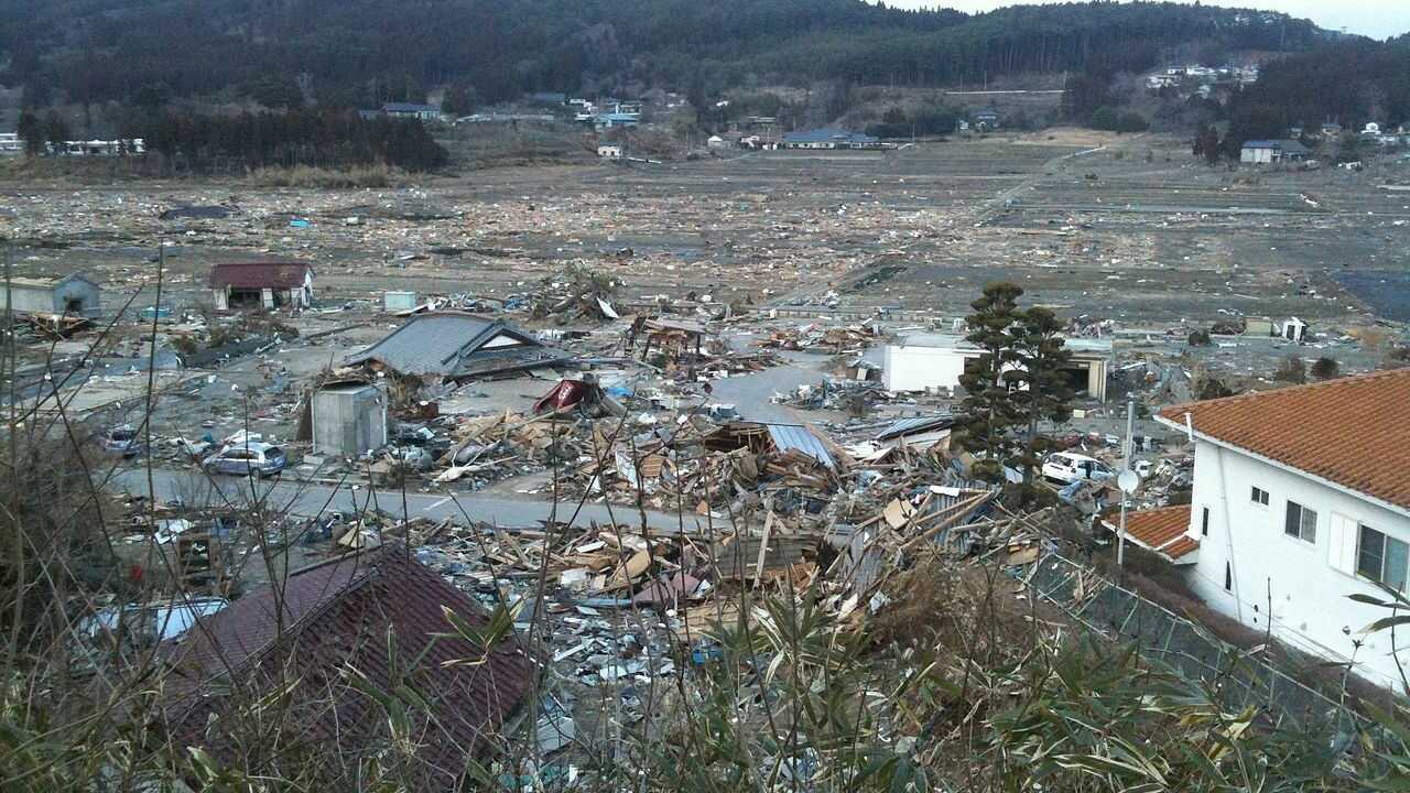
“Large tsunamis were known to have occurred in the past from earthquakes in the Japan trench from historical records as well as geological evidence of tsunami deposits along Japan’s east coast. The 2011 Tōhoku tsunami runups reached a maximum of 40m, and were higher than 20m along 200km of Tōhoku coast.
“The large tsunami was estimated to have been caused by the large fault slip near the trench. Horizontal slip displacements of more than 30m were recorded at underwater geodetic stations.
“Scientific drilling into the rupture zone near the trench revealed that the plate boundary was confined by a layer of pelagic clay. The weakness of this clay layer may help to explain the very large slip. The probability of another M9 earthquake soon in this region is low.
“However, the stress state after the 2011 Tōhoku thrust earthquake might bring other types of tsunamigenic earthquakes closer to rupture. The earthquake has already been followed by one normal-faulting event that generated small tsunami.”
No conflict of interest declared.
Dr Emily Lane, hydrodynamics scientist, NIWA, comments:
“The 11 March 2011 Tōhoku-oki earthquake and tsunami happened just weeks after the 22 February 2011 Christchurch Earthquake and so the usual psychological tricks that allow us to think ‘that only happens in distant places on the other side of the world’ just didn’t work any longer. Many people were glued to the television, watching the tsunami waves overtopping the huge seawalls, inundating inland and thinking – is this what’s happening next?
“Here in Ōtautahi Christchurch we are not living just inland from a subduction zone, but the North Island has the Hikurangi and Tonga-Kermadec Subduction Zones lying just offshore. The Tonga-Kermadec Trench is the longest, straightest subduction zone in the world and a magnitude 9+ megathrust earthquake and resulting tsunami is possible. Just last week we were reminded that large earthquakes can happen on this subduction zone, and while that magnitude 8.1 earthquake near the Kermadec Islands thankfully did not cause a significant tsunami in Aotearoa New Zealand, it shouldn’t be written off.
“These megathrust earthquakes happen relatively infrequently and so every time one does occur we learn more and have to reassess what we think we know about them. The magnitude of the 2011 Tōhoku-oki earthquake and the consequent movement of the sea floor have led to a recalibration of what is possible. Japan has a long history of tsunamis extending at least as far back as the Jōgan event of 869 CE – over a thousand years ago. Aotearoa New Zealand has a comparatively short tsunami history. By integrating different knowledge streams including Māori oral traditions and palaeotsunami deposits we can see further back in time. But we still rely on scientific information from other subduction zones around the world, including Japan, to understand our tsunami hazard. The research into the Tōhoku-oki earthquake and tsunami over the last ten years adds to our understanding of these processes.
“Ongoing research is helping us understand the likelihood of megathrust earthquakes on our subduction zones. The recent New Zealand DART buoy deployment and the Rapid CET Endeavour programme will help us determine whether a large earthquake has generated a dangerous tsunami. Regardless of this research, if you are near to the coast and experience a long or strong earthquake, get yourself to higher ground immediately. There will be plenty of time to find out the scientific details afterwards.”
No conflict of interest declared.
Professor Tim Stern, School of Geography, Environmental and Earth Science, Victoria University, comments:
“I clearly recall March 11, 2011. I was on the west coast of the South Island with a group of students doing some geophysical measurements and servicing a seismic array that we had installed in the central portion of the Southern Alps. We knew something was up when carrying out tests with our seismic and gravity instruments, we found them to be swamped by seismic surface waves that were circling the earth in the aftermath of the magnitude 9 Tōhoku event. Once we got back to town (Hari Hari) we learnt about the devastating destruction of this quake and its consequent tsunami. At that time I recall feeling somewhat shocked and didn’t really think about its relevance to New Zealand.
“In the 2 years following the Tōhoku quake a consortium of New Zealand and overseas organisations carried out an important seismic imaging project of the interface between the Australian and Pacific plates, that sits beneath Wellington City. At plate boundaries where one plate plunges beneath another, it is called a subduction zone. It is these regions of the earth where almost all the large earthquakes occur.
“This Wellington experiment across the Hikurangi Subduction Zone had been proposed and funded prior to the Tōhoku quake, but it turns out that the results of the work had particular relevance in light of the Tōhoku event. What we did was carry out a seismic survey from the Kapiti coast to the eastern Wairarapa coast that provided x-ray like images of the earth’s crust and upper mantle to depths in excess of 50 km. What we could see in these images was that the interface between the two plates is about 25 km deep and it plunges down to the north west at an angle of about 10 degrees.
“It turns out there are strong parallels in setting between Tōhoku and the southern North Island. Both areas are underlain by a subduction zone where the depth of the plate interfaces is about 25 km, and the angle of the interfaces are both 10-20 degrees. Furthermore, it turns out a 20-30 km depth, on a subduction interface was the setting for most of the other magnitude 9 quakes that have been recorded in the past 60 years: i.e. Chile, 1960, Alaska, 1964 and Sumatra, 2004.
“This comparison may at first appear worrying, but there are differences between the southern North Island and the above mentioned localities for magnitude 9 earthquakes. The most obvious one is the southern North Island being above sea level, while the others are all located between 10 and 200 km offshore. We are currently exploring these differences and similarities in an attempt to get a sense of whether our subduction zone is capable of producing rare Magnitude 9 events, or merely Magnitude 7-8 events on a more regular time interval. Hopefully the latter!”
No conflict of interest declared.
Dr Jennifer Eccles, Senior Lecturer, School of Environment, University of Auckland, comments:
“The resources invested in earthquake and tsunami research in Japan are the envy of scientists around the world. A world-leading network of land-based seismometers, GPS stations and ocean floor sensors were in place prior to the devastating magnitude 9 Tōhoku earthquake and tsunami in Japan and additional resources were mobilised quickly after the event to drill through the rupture zone in the deep ocean offshore Japan. This has allowed detailed study of earthquake and tsunami dynamics that has in many ways highlighted the complexity of such systems and the role of geological heterogeneity in controlling how an individual event will manifest.
“Even the pre-event understanding of the Japanese system exceeded what New Zealand has achieved today and this has resulted from, and manifests in, key differences between our nations. Japan has historically experienced many large earthquakes and tsunamis from their subduction zones with the increasingly large population, and population density, exposed to these hazards through time increasing their risk. This is driving investment in understanding the hazard and trying to mitigate it through engineering, technology and education.
“In New Zealand we have yet to suffer loss of life from a tsunami sourced immediately off of our coast and our risk to people and property is, while very significant to us, much smaller in comparison. Although NZ has lead the way on many aspects of earthquake science in the past, our investment in offshore technology has really only begun in the last 5 years but with our own innovation and Japan’s and others experience leading the way, we continue to better understand our own hazards and improve our infrastructure to respond and communicate in the event of an emergency.
“While our science and disaster management investment and resources will always be in line with the size of our nation and economy our real strength in New Zealand lies in the people and their willingness to engage with understanding our geological hazards, and respond appropriately when there is any indication it is needed to preserve their own lives and those of their loved ones, as demonstrated by the actions seen during the tsunami warnings on Friday 5th March.”
No conflict of interest.
Professor John Townend, School of Geography, Environment, and Earth Sciences, Victoria University of Wellington; and president-elect of the Seismological Society of America, comments:
“In the decade that has passed since the devastating magnitude 9 Tōhoku-oki earthquake of 11 March 2011, scientists have learned an incredible amount about the processes involved in such large earthquakes, the mechanisms by which large tsunami are generated, and the potential for similarly large earthquakes in other parts of the world.
“The Tōhoku-oki earthquake occurred off the eastern coast of northern Honshū within the northeastern Japan Subduction Zone. Here, the Pacific plate is being thrust below part of the North American plate along the Japan Trench, at a rate of more than 8cm per year. (This geometry is similar to that of the Hikurangi Subduction Zone along the eastern coast of the North Island, where the Pacific is being pushed below the Australian plate at something like 4cm per year.) The earthquake occurred on the principal fault separating the two plates when one side of the fault slipped by as much as several tens of meters with respect to the other, over an area of approximately 60,000 square kilometers, or an area about half that of the North Island of New Zealand.
“The very large tsunami produced by the earthquake was responsible for most of the 18,550 fatalities and damage to infrastructure, including the Fukushima nuclear power plants. The key reason why the tsunami was so large was that slip occurred all the way to the seabed along the fault that produced the earthquake. In fact, as much as 50m of slip occurred along the shallow portions of the fault, causing a massive displacement of the seabed and disruption to the water column that collapsed and produced the tsunami.
“Prior to the earthquake, earthquake scientists did not consider slip to be possible at such shallow depths, due to the frictional properties of rocks forming major faults. Shortly after the earthquake, the Japanese scientific drilling ship Chikyū, which had itself been damaged during the earthquake, was deployed to drill into the fault to retrieve rock and fluid samples and measure temperatures in order to determine how such extensive slip had occurred. Operating in almost 7km water depths, Chikyū drilled more than 800m beneath the seabed to intersect the fault that slipped during the earthquake. In conjunction with the seismological and geodetic measurements made during the earthquake, and subsequent seabed surveys, the drilling results showed unequivocally that the weak rocks lining the fault were capable of extensive slip at shallow depths.
“Part of the reason so much has been learned scientifically since the 2011 Tōhoku-oki earthquake is that the area surrounding the earthquake’s epicenter had been recognised prior to 2011 as the likely source of a large earthquake. The likelihood of a magnitude 7.5-8.0 earthquake occurring in the next 30 years had been estimated to exceed 90%. In response, this portion of the Japan Trench was extensively instrumented with seabed seismometers, pressure gauges and positioning sensors, and surveyed using sophisticated ship-borne imaging equipment.
“The data recorded during and after the earthquake by the seabed instruments, by repeated re-surveying of the region by ships, and direct in situ sampling via drilling provided unprecedented insight into what happened during the earthquake and how deformation of the seabed produced such a devastatingly large tsunami. This insight provides a basis for further steps by Japan and all locations exposed to earthquake hazard – not least New Zealand – to prepare for and mitigate the effects of future earthquakes.
“The Tōhoku-oki earthquake has also resulted in a global re-reckoning of how large an earthquake a particular plate-bounding fault can produce. It has been recognised since the mid-twentieth century that subduction zones, where one tectonic plate is forced down beneath another, produce the largest earthquakes, exemplified by the magnitude 9.5 Great Chilean earthquake in 1960 and the magnitude 9.2 Great Alaska earthquake in 1964. However, whether all subduction zones, including both the northern Japan Trench and New Zealand’s Hikurangi Subduction Zone, could produce such large earthquakes and correspondingly large tsunami was less well understood.
“In light of observations made during the 2011 Tōhoku-oki earthquake, in a location not thought beforehand to generate earthquakes larger than magnitude 8, it is now accepted that many if not most subduction zones can produce extremely large earthquakes. This has clear ramifications for New Zealand. Collaborative research undertaken by New Zealand scientists and international colleagues in the decade since the Tōhoku-oki earthquake has revealed that the potential for magnitude 9 earthquakes in the Hikurangi Subduction Zone off the eastern coast of the North Island must be considered in hazard planning and mitigation.
“Finally, even though a decade has passed since the 2011 earthquake, northern Japan still faces substantial seismic hazard. Some of this hazard is posed by ongoing aftershocks but, in addition, there is potential for large (magnitude~8) earthquakes occurring within the Pacific plate (rather than on the interface between the Pacific and North American plates), as observed following large subduction zone earthquakes in 1933 and 2007. As part of efforts to determine how much strain is accumulating in the Pacific plate today, geophysicists must disentangle the effects of viscoelastic flow occurring in the mantle beneath Japan from ongoing slip on the 2011 fault plane. The extensive monitoring instrumentation deployed on the seabed and on land surrounding the 2011 rupture area enable those two effects to be separately measured and accounted for. These efforts will provide new insight into the long-term effects of large subduction zone earthquakes, but it is still not possible to predict the time, location, or magnitude of any specific earthquake in other than a statistical sense.”
Note: John has previously lived and worked in Japan, and conducted seismological research there, and was involved in discussions in Tokyo immediately following the Tōhoku-oki earthquake that led to the rapid-response drilling programme.
No conflict of interest.