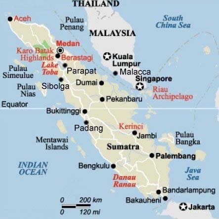
Following the devastating earthquake and tsunami in the Samoan islands, an earthquake off the coast of Sumatra has also caused widespread damage and loss of life.
The Science Media Centre in the UK gathered these comments from experts on yesterday’s seismic events.
 Dr Dave Rothery, volcanologist and planetary scientist at the Open University in Britain comments on the earthquake in the Samoan islands:
“…this tsunami was caused by an undersea earthquake, at a subduction zone where one tectonic plate is being pushed down below another. In this example, the floor of the Pacific ocean is being pushed westwards below the Tonga island arc. Plates do not slide past each other smoothly. Instead, strain builds up until the deformation is relieved in a major jerk. In this case, the ‘jerk’ began at a relatively shallow depth of about 18 km, and the seafloor above it was probably jolted upwards by several metres. This sudden displacement caused a series of waves on the sea surface, which became higher and steeper when they ran ashore. Local reports speak of waves reaching more than 5 metres above sealevel and rushing 100 metres inland.”
Dr Rothery on the earthquake off Sumatra:
“The earthquake offshore of Sumatra was powerful but fortunately did not trigger a damaging tsunami, perhaps because it happened about 50 miles (80 km) down. The nearby rupture that caused the Indian Ocean tsunami on 26 December 2004 was much shallower. Both were caused by the same process – the floor of the Indian Ocean is being dragged down northeastwards below Indonesia. The motion is not smooth, but goes in fits and starts. When a sudden jerk happens, that’s what causes an earthquake, and sometimes a tsunami if the epicentre is below the sea but not too deep.
“Unfortunately however the ground-shaking in Padang was enough to collapse the roofs of many buildings. Probably if buildings, notably hospitals, had been better constructed fewer people would have died. Often it is schools – built at public expense but on the cheap – that fall down. Maybe that is a story that will emerge from Padang too, though because the quake was after 5pm local time maybe the schools were empty by then.”
Professor Bill McGuire, Professor of Geophysical & Climate Hazards and Director of the Aon Benfield UCL Hazard Research Centre, comments on the tsunami that hit Samoa:
“This most recent tsunami disaster shows that there are lessons we yet need to learn from 2004. Most critically, populations living close to faults capable of producing earthquakes that trigger tsunamis must be taught to self-evacuate when the ground shakes or the sea recedes. Waiting for a warning from a central monitoring station could mean the difference between life and death”
And courtesy of the AusSMC:
Gary Gibson is Senior Seismologist at Environmental Systems and Services, based in Melbourne, and is Chairman of the Executive Committee of the International Seismological Centre. He is an Honorary Research Associate in the School of Geosciences at Monash University:
“The earthquake south of Samoa [yesterday] occurred at 06.48 AM Samoa time (03.48 AM Eastern Australian Standard Time). It was located 200 km south of Samoa, north of Tonga and northeast of Fiji, and was at a shallow depth.
“The earthquake had a moment magnitude of about 8.0, which corresponds to a rupture within the earth that may be 200 to 300 km long, with a depth of 100 to 200 kilometres, with one side of the fault moving 4 to 7 metres relative to the other. This is quite large enough to deform the sea floor and generate a tsunami, but the size and pattern of the tsunami depend on the amount and orientation of the sea-floor deformation.
“The earthquake magnitude and deformation were much less than in the rare huge earthquakes of magnitude 9.0 and higher, such that off Chile in 1960, and the Boxing Day 2004 earthquake off Sumatra. The fault length for those was greater than 1000 kilometres, and the plates moved 10 to 20 metres or more relative to each other. For the Samoa earthquake, this meant that a devastating tsunami could be produced locally, but it was unlikely to seriously affect countries on the boundary of the Pacific.
“The earthquake occurred at the north end of a major north-south tectonic plate boundary, the Tonga-Kermadec Trench, where the Pacific Plate is subducted to the west under the Australian Plate.
“The USGS has determined that the earthquake was due to northeast to southwest tension, with the earth being stretched rather than compressed. This leads to faulting that is oriented southeast to northwest, with vertical motion that will deform (and possibly rupture) the sea-floor, producing a tsunami.
“This earthquake mechanism suggests that the earthquake was not precisely along the plate boundary, but was within the Pacific Plate where it has been bent over to the west and southwest as it enters the subduction zone.
“The mechanism and the aftershock distribution suggest that the earthquake rupture propagated from the epicentre at the southeast towards the northwest, and not to the south on the much longer and larger Tonga-Kermadec Trench. Beyond the rupture, the plate boundary then gradually turns to the west and passes north of Fiji.
“The orientation of the faulting would have generated a tsunami with higher waves to the northeast (towards Samoa) and to the southwest (towards Tonga, eastern Fiji, and beyond towards New Zealand and the Tasman Sea). This may well have seriously affected communities on isolated islands, especially in Tonga and Fiji. Hopefully, authorities will be urgently contacting these people.”