Scientists are still unravelling what happened a week ago on several faults near Kaikoura and Culverden.
We asked GeoNet scientists about what they have been finding out.
 What do we know about the possibility of stress added to neighbouring faults?
“We understand this is an important question. We are currently developing the model for this particular earthquake sequence. Teams are inspecting on-land fault ruptures and feeding other data into the model, which will also help us understand fault stress. Stress does not always increase stress on the neighbouring faults, it can sometimes decrease the stress loading. We are uncertain when we will be able to provide information about any changes in stress loadings.
“GeoNet has advised that the chance of a further shock in the Wellington area has increased somewhat since the Kaikoura Earthquake, and these faults and the subduction interface beneath Wellington are captured in our probability table and scenarios.
“Information on New Zealand’s major faults is available on the GNS Science website.”
This seems like an unusual earthquake sequence, with multiple faults rupturing – how does this event fit with existing models?
“This earthquake sequence aligns well with our understanding of New Zealand tectonics but it is very complex. This area of North Canterbury and Marlborough is where we would expect a lot of surface faulting (faults in the upper crust).
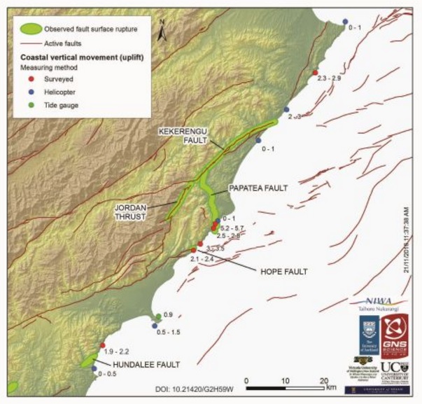
“This was an interesting earthquake and has included at least six faults rupturing. GeoNet has advised that in New Zealand quite a few of our larger earthquakes involve jumping from rupture on one plane to another in a complex sequence. This includes the Darfield September 2010 quake where multiple segments ruptured together as a single earthquake.”
What does this earthquake sequence mean for calculating aftershock probabilities?
“Aftershock probabilities are based on data from previous earthquake sequences that have occurred around the world. Most earthquake aftershock sequences decay over time, with spikes of activity and occasional larger earthquakes. We use probabilities as we cannot predict earthquakes, these describe the likely progression of the sequence within the next day, week and month. The scenarios specifically address what we expect within the next 30 days, however, we expect aftershocks to continue for months to years. GeoNet has provided a number of updates regarding probabilities.”
Are there any examples overseas that compare to this multiple-fault earthquake?
‘Yes, there are many examples. Multiple-fault earthquakes often occur in the upper crust in continental interiors, especially in regions where there are multiple faults that are located close together. There are other examples of this in California.’
What led to the initial 7.5 magnitude estimate and what information changed it to a 7.8 magnitude?
“The original estimate was based on seismic waves observed by New Zealand seismometers. The revision of the magnitude of the earthquake to M7.8 was on the basis of additional information including:
- analysis of seismic waves recorded at distant GeoNet stations (the rupture lasted over one minute, meaning standard methods of calculating magnitudes were insufficient to capture the full energy released);
- GPS ground deformation and strong motion data;
- the length of the faults involved, observed from field reconnaissance.
“The revised magnitude is consistent with measures of this earthquake from France, Germany, US and Japan. GeoNet provided more information when the revision was made.”
Does the change in magnitude change anything about what we know about the earthquake, beyond altering the aftershock probabilities?
“No, the change just better matches the slip we observe along the faults and in our model.”
What has changed and what have we learned since the Canterbury earthquakes, and how is that helping get information and communicate it with the public?
“We have many more sensors, better GPS information, and access to more data such as from satellites and LiDAR. Thanks to additional funding from the Earthquake Commission we have upgraded the GeoNet processors, the website and app to provide more immediate information and to cater for increasing traffic volumes. New Zealand is one of the most instrumented countries on the planet, and so we are well placed to understand this earthquake.
“The Canterbury earthquakes have helped us learn what to look for, for example, where landslides may occur. Lessons from Canterbury have been incorporated into many aspects of our response, for example in better understanding how people are feeling and the need to provide rapid and detailed information, and how best to communicate the information that is wanted. GeoNet has provided information on the landslides and landslide dams.”